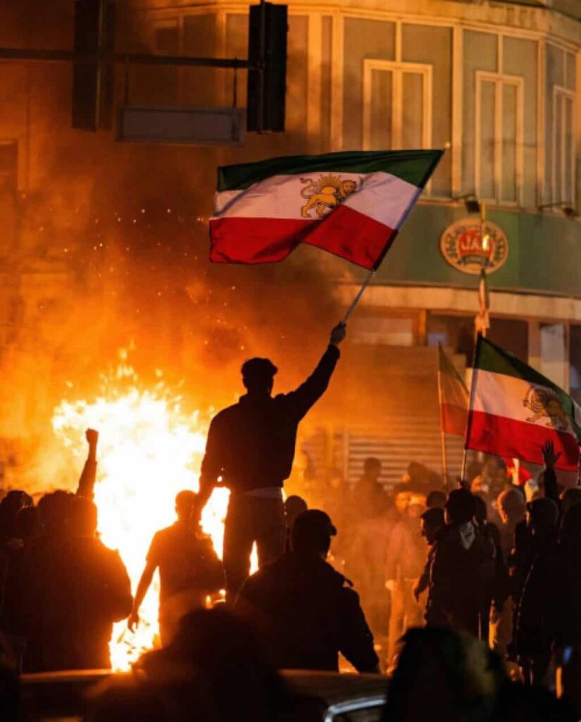
“Maps are the product of power, and they produce power,” as stated by Geographer J Brian Harley. In 2023, the release of a new “standard map” by China’s Ministry of Natural Resources drew strong reactions from at least six or seven countries due to its expansive territorial claims. The map particularly angered China’s neighbours, as it included not only Taiwan but also portions of the maritime zones of the Philippines, Vietnam, Brunei, Indonesia, and Malaysia, as well as disputed land belonging to India and even territory belonging to Russia, so-called China’s ally.
This is not the first time China has used cartography to project power and assert control in this region. Beijing has been doing so over the years through repeated visual dash lines, massive island-naming campaigns, repeated toponymy of borderland/ethnic regions, artificial-island reclamation, and renaming. These are not random incidents, but systemic, iterative changes used as part of a broader strategy to create facts and justify subsequent administrative or coercive steps.
This is psychological warfare, as maps serve as critical instruments in shaping global public opinion on territorial disputes. They function as ideological tools for educating populations, shaping perceptions, and fostering a collective national consciousness. By changing the map, one can change how the world is viewed. Repeated map publications condition domestic and foreign audiences to perceive Chinese claims as legitimate, an effect explained by the illusory truth effect in Psychology.
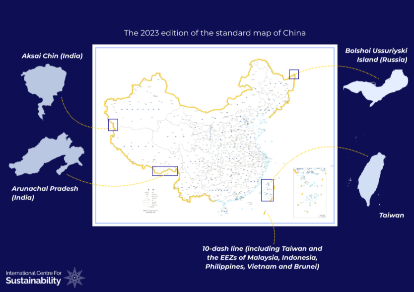
Figure 1 : The standard map released by China in 2023, claiming maritime zones and territories belonging to several countries as its own.
Legal, Economic and Security Implications
China’s cartographic aggression is a strategic weapon with legal, security, and economic implications, challenging the vision of a free and open Indo-Pacific. Legally, it undermines international law by disregarding the 1982 UN Convention on the Law of the Sea (UNCLOS) and the binding 2016 Hague Tribunal ruling that invalidated the nine-dash line. On the security front, China’s maritime claims in the South China Sea and its assertion of control over disputed territories create potential flashpoints in the Indo-Pacific region. Economically, the region is extremely significant as it accounts for 65 percent of the world’s population, 63 percent of the world’s GDP, and 46 percent of the world’s merchandise trade and 50 percent of the world’s maritime trade. Beijing’s claims in the South China Sea position it to control or choke supply chains, potentially impacting all key players in the Indo-Pacific region.
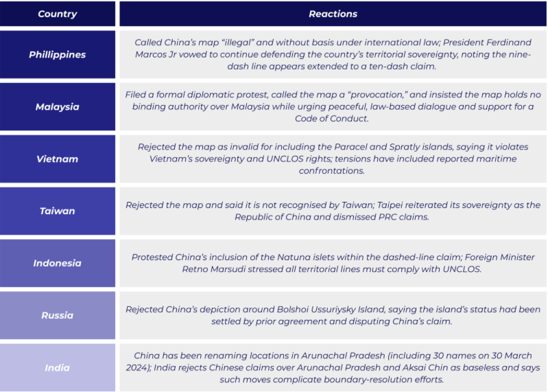
Figure 2: Official reactions to China’s 2023 standard map by multiple countries directly affected by its claims.
Blind spot in the Western Strategy
While China’s standard map received sharp reactions from countries directly affected by it, the response from the West was limited, unclear, and insufficient, highlighting a blind spot in Western strategy in the Indo-Pacific region. The territories claimed by this map in the Himalayas and the South China Sea are part of China’s expansionism, which has implications for all key stakeholders in the Indo-Pacific.
The U.S. gave the clearest legal rejection of the map’s maritime claims. Most European governments (UK, France, Germany, EU institutions) framed their responses around coercive conduct, safety and UNCLOS, rather than issuing a single-sentence legal denial of the 2023 map itself. None of the countries, including the US condemned China’s territorial claims in the Himalayas. Often, territorial disputes in the Himalayas are viewed separately from the issues in the South China Sea, a perspective that is rapidly changing.
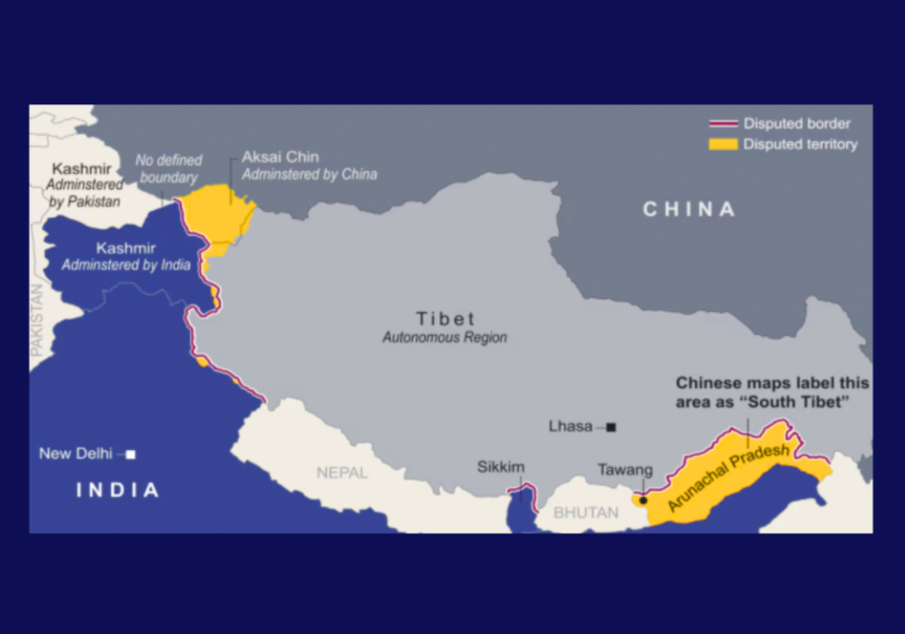
Figure 3: Territories in Himalayas (Aksai Chin and Arunachal Pradesh) illegitimately claimed by China in the 2023 map. Source: Reuters
If India, emerging as a net security provider in the Indo-Pacific, is embroiled in border disputes and militarisation due to China’s territorial claims, it will remain occupied in the Himalayas while instability continues in the South China Sea. In essence, flashpoints in the Himalayas (Aksai Chin and Arunachal Pradesh in Fig. 3), particularly the India-China border tensions, constrain India’s Indo-Pacific strategy, forcing it to prioritise border security. This hinders India’s ability to project its influence in the Indo-Pacific and introduces uncertainty and complexity into broader regional dynamics.
Preserving a Free, Open, and Rules-Based Indo-Pacific
A multifaceted approach that raises the legal, reputational, economic, and technical costs of unilateral changes to maps is necessary, as cartographic aggression thrives on cheap repetition, amplification and adoption by neutral third-party. There is an urgent need to introduce a form of regulation that governs the usage of maps and the consequences for not adhering to such regulation at the international level.
Firstly, countries such as the US, UK, and the EU, which advocate for a free, open, and rules-based Indo-Pacific, should openly condemn China’s unilateral actions and reject the map entirely. This is crucial because claims in the South China Sea and the Himalayas significantly impact the Indo-Pacific strategy, and a clear rejection, free from ambiguity, is necessary to prevent unilateral map changes from becoming a future norm. Current silence especially in the Himalayas allows China to solidify its claims without consequence.
Secondly, condemnation alone is insufficient to counter China’s grey-zone tactics in the Indo-Pacific region, as China’s interests outweigh the costs. Prioritising legal and reputational pressure on the international stage, through ICJ advisory opinions or UNGA resolutions concerning unilateral name changes and territorial claims by China, would set a precedent not only for China but for any country making such claims in the future.
Thirdly, key stakeholders in the Indo-Pacific should advocate for a “Responsible Mapping Code of Conduct” to ensure tech platforms, publishers, and logistics firms do not become inadvertent vehicles for Beijing’s territorial claims. Also, introducing mandatory “disputed” markers and disclaimers on contested areas, thereby limiting their worldwide dissemination.
Conclusion
China’s cartographic aggression extends beyond mere lines on a map it represents the psychological shaping of the geopolitical battlefield. The result is a weakened rules-based order, and a dangerous precedent for unilateral territorial expansion. For the UK, US, and other Indo-Pacific partners, the question is no longer whether to respond, but how, because every unchallenged map redraws the balance of power. Establishing robust regulations and frameworks to counter such unilateral actions is crucial for safeguarding the principles of a free, open, and rules-based Indo-Pacific.